
Tel-Aviv topographic map
Interactive map
Click on the map to display elevation.
About this map
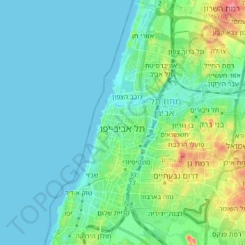
Name: Tel-Aviv topographic map, elevation, terrain.
Location: Tel-Aviv, Tel Aviv Subdistrict, Tel-Aviv District, Israel (32.02934 34.73913 32.14698 34.85226)
Average elevation: 17 m
Minimum elevation: 0 m
Maximum elevation: 89 m
Other topographic maps
Click on a map to view its topography, its elevation and its terrain.
Holon
Holon, Tel Aviv Subdistrict, Tel-Aviv District, Israel
Average elevation: 33 m
Yarkon River Mouth Lighthouse
Israel > Tel-Aviv District > Tel-Aviv
Yarkon River Mouth Lighthouse, Rehavam Zeevi, Tel Aviv, Sde Dov Area, Tel-Aviv, Tel Aviv Subdistrict, Tel-Aviv District, 6340506, Israel
Average elevation: 5 m
Bat Yam
Bat Yam, Tel Aviv Subdistrict, Tel-Aviv District, Israel
Average elevation: 21 m
Ramat Gan
Ramat Gan, Tel Aviv Subdistrict, Tel-Aviv District, Israel
Average elevation: 35 m