
Thank you for supporting this site ❤️
Make a donation
Make a donation
Düdinghausen topographic map
Click on the map to display elevation.
Thank you for supporting this site ❤️
Make a donation
Make a donation
About this map
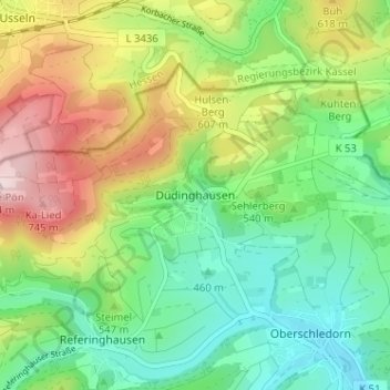
Name: Düdinghausen topographic map, elevation, terrain.
Average elevation: 541 m
Minimum elevation: 404 m
Maximum elevation: 776 m
Thank you for supporting this site ❤️
Make a donation
Make a donation
Other topographic maps
Click on a map to view its topography, its elevation and its terrain.
Kahle Pön
Deutschland > Nordrhein-Westfalen > Hochsauerlandkreis > Medebach > Titmaringhausen
Average elevation: 623 m
Knickhagen
Deutschland > Nordrhein-Westfalen > Hochsauerlandkreis > Medebach > Oberschledorn
Average elevation: 472 m