
Thank you for supporting this site ❤️
Make a donation
Make a donation
Bhubaneshwar topographic map
Click on the map to display elevation.
Thank you for supporting this site ❤️
Make a donation
Make a donation
Bhubaneshwar
Bhubaneswar is in Khordha district of Odisha. It is in the eastern coastal plains, along the axis of the Eastern Ghats mountains. The city has an average altitude of 45 m (148 ft) above sea level. Bhubaneswar lies in Mahanadi River Delta. The Daya River is 4 km to the south and the Kuakhai River 4 km to the east; the Chandaka Wildlife Sanctuary and Nandankanan Zoo are in west and north to Bhubaneswar, respectively.
Thank you for supporting this site ❤️
Make a donation
Make a donation
About this map
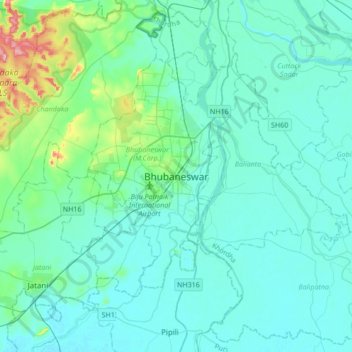
Name: Bhubaneshwar topographic map, elevation, terrain.
Average elevation: 30 m
Minimum elevation: 6 m
Maximum elevation: 199 m
Thank you for supporting this site ❤️
Make a donation
Make a donation