
Make a donation
Death Valley topographic map
Click on the map to display elevation.
Make a donation
Death Valley
Death Valley's Badwater Basin is the point of lowest elevation in North America, at 282 feet (86 m) below sea level. It is 84.6 miles (136.2 km) east-southeast of Mount Whitney, the highest point in the contiguous United States, with an elevation of 14,505 feet (4,421 m). On the afternoon of July 10, 1913, the United States Weather Bureau recorded a high temperature of 134 °F (56.7 °C) at Furnace Creek in Death Valley, which stands as the highest ambient air temperature ever recorded at the surface of the Earth. This reading, however, and several others taken in that period, a century ago, are in dispute by some modern experts.
Make a donation
About this map
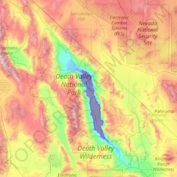
Name: Death Valley topographic map, elevation, terrain.
Location: Death Valley, California, 92328, United States (35.55151 -117.65105 37.29602 -116.25764)
Average elevation: 1,085 m
Minimum elevation: -83 m
Maximum elevation: 3,329 m
Make a donation
Other topographic maps
Click on a map to view its topography, its elevation and its terrain.
Cobb
United States > California > Lake County
Cobb is a census designated place (CDP) in Lake County, California, United States. Cobb is located 1 mile (1.6 km) northwest of Whispering Pines, at an elevation of 2,631 feet (802 m). The population was 1,778 at the 2010 census, up from 1,638 at the 2000 census.
Average elevation: 887 m
Bombay Beach
The derelict "living ghost town" status of Bombay Beach has attracted many photographers, filmmakers, urban explorers, and tourists, to the point that locals tend to ask visitors if they are filmmakers that are there to shoot a documentary. The town, as well as others on the shores of the Salton Sea, is one of…
Average elevation: -61 m
Make a donation