
Argentina topographic map
Interactive map
Click on the map to display elevation.
About this map
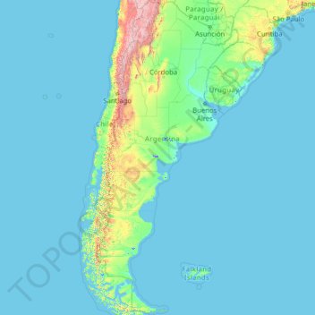
Name: Argentina topographic map, elevation, terrain.
Location: Argentina (-55.18508 -73.56054 -21.78086 -53.63745)
Average elevation: 198 m
Minimum elevation: -2 m
Maximum elevation: 6,482 m
Major wind currents include the cool Pampero Winds blowing on the flat plains of Patagonia and the Pampas; following the cold front, warm currents blow from the north in middle and late winter, creating mild conditions. The Sudestada usually moderates cold temperatures but brings very heavy rains, rough seas and coastal flooding. It is most common in late autumn and winter along the central coast and in the Río de la Plata estuary. The Zonda, a hot dry wind, affects Cuyo and the central Pampas. Squeezed of all moisture during the 6,000 m (19,685 ft) descent from the Andes, Zonda winds can blow for hours with gusts up to 120 km/h (75 mph), fueling wildfires and causing damage; between June and November, when the Zonda blows, snowstorms and blizzard (viento blanco) conditions usually affect higher elevations.
Other topographic maps
Click on a map to view its topography, its elevation and its terrain.
Gualeguaychu
Argentina > Entre Ríos Province > Distrito Costa Uruguay Sur
Gualeguaychu, Gualeguaychú, Distrito Costa Uruguay Sur, Departamento Gualeguaychú, Entre Ríos Province, Argentina
Average elevation: 12 m
San Carlos de Bariloche
Argentina > Río Negro Province
San Carlos de Bariloche, Municipio de San Carlos de Bariloche, Departamento Bariloche, Río Negro Province, 8400, Argentina
Average elevation: 1,042 m
Trenque Lauquen
Argentina > Buenos Aires > Trenque Lauquen
Trenque Lauquen, Partido de Trenque Lauquen, Buenos Aires, Argentina
Average elevation: 94 m