
Make a donation
Roubaix topographic map
Click on the map to display elevation.
Make a donation
Roubaix
The land upon which Roubaix stands belongs to the plain of Flanders. The Roubaisian area stretches on an east-west oriented shallow syncline axis which trends south-southeast to the Paleozoic limestone of the Mélantois-Tournaisis faulted anticline. It consists predominantly of Holocene alluvial sediment depositions. It is flat and low, with an elevation drop of only 35 m (114 ft 10 in) over its 13.23 square kilometres (5.11 sq mi). The lowest altitude of this area stands at 17 m (55 ft 9+1⁄2 in), while its highest altitude is 52 m (170 ft 7 in) meters above the sea level.
Make a donation
About this map
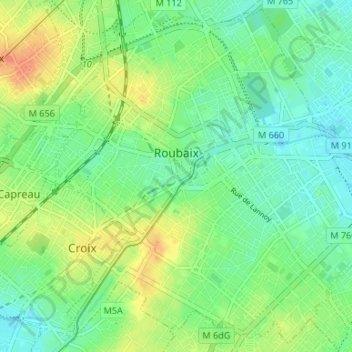
Name: Roubaix topographic map, elevation, terrain.
Average elevation: 37 m
Minimum elevation: 21 m
Maximum elevation: 62 m
Make a donation
Other topographic maps
Click on a map to view its topography, its elevation and its terrain.
Make a donation
Make a donation