
Make a donation
Aix-les-Bains topographic map
Click on the map to display elevation.
Make a donation
Aix-les-Bains
Aix-les-Bains is located in the southeast of France, 107 kilometres (66 mi) east of Lyon. The town is located in a corridor between the mountain of Mont Revard, the first natural rampart of the Massif des Bauges to the east and the Lac du Bourget, the largest natural lake of France to the west. Thus, the city extends mostly on a north–south axis. Its extension is such that its agglomeration merges gradually with that of Chambéry. The area of the commune is 12.62 square kilometres (4.87 sq mi), which is large for the department. The town is traditionally divided into two, the lower town that occupies the banks of the lake to the west and the upper town, where the town centre is located, overlooking the Lac du Bourget. The town was first built on the heights in order to avoid the many floods of the lake until it was regulated by the dam of the Compagnie Nationale du Rhône (CNR) between the Rhône and the natural spillway of lake, the Canal de Savières. The average altitude of the city is about 320 metres (1,050 ft) while the lower part of it is only around 224 metres (735 ft), at the level of the lake.
Make a donation
About this map
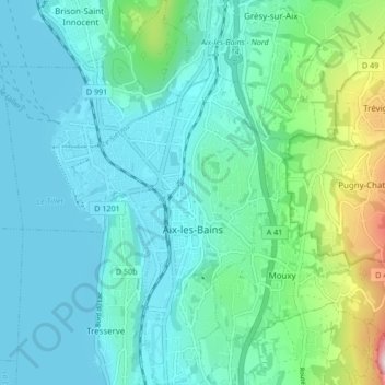
Name: Aix-les-Bains topographic map, elevation, terrain.
Average elevation: 348 m
Minimum elevation: 227 m
Maximum elevation: 897 m
Make a donation
Other topographic maps
Click on a map to view its topography, its elevation and its terrain.
Barrage de Roselend
France > Auvergne-Rhône-Alpes > Savoy > Beaufort
The dam has a maximum height of 150 m (492 ft) and a length of 804 m (2,638 ft). It is 3 m (10 ft) wide at its crest and 22 m (72 ft) wide at its base. The dam has a structural volume of 945,000 m3 (1,236,013 cu yd). Its reservoir, Lac de Roselend, can store 187,000,000 m3 (151,603 acre⋅ft) of water and has…
Average elevation: 1,598 m
Les Granges
France > Auvergne-Rhône-Alpes > Savoy > Saint-Martin-de-Belleville
Average elevation: 1,803 m
Saint-Jean-de-Maurienne
France > Auvergne-Rhône-Alpes > Savoy > Saint-Jean-de-Maurienne > Saint-Jean-de-Maurienne
Average elevation: 1,089 m
Make a donation
Val Thorens
France > Auvergne-Rhône-Alpes > Savoy
Val Thorens ([val tɔʁɑ̃]) is a ski town in the Tarentaise Valley in the French Alps at an altitude of 2,300 m (7,500 ft). It is located in the commune of Saint-Martin-de-Belleville in the Savoie department. The resort forms part of the Les Trois Vallées ski area which, with over 600 km of slopes, is one…
Average elevation: 2,516 m
Make a donation
Col de l'Iseran
France > Auvergne-Rhône-Alpes > Savoy > Bonneval-sur-Arc
On both sides of the Col de l'Iseran, mountain pass cycling milestones mark the distance to the summit, the current altitude, and the average slope in the following kilometre.
Average elevation: 2,779 m
Val Thorens
France > Auvergne-Rhône-Alpes > Savoy
Val Thorens ([val tɔʁɑ̃]) is a ski town in the Tarentaise Valley in the French Alps at an altitude of 2,300 m (7,500 ft). It is located in the commune of Saint-Martin-de-Belleville in the Savoie department. The resort forms part of the Les Trois Vallées ski area which, with over 600 km of slopes, is one…
Average elevation: 2,516 m
Lac du Mont-Cenis
France > Auvergne-Rhône-Alpes > Savoy > Val-Cenis
Mont-Cenis Lake is a lake located in the Mont-Cenis massif at an altitude of 1,974 meters (6,476 ft) in the municipality of Val-Cenis in France. It is situated at the top of the Cenise valley, on the Italian side of the Mont-Cenis pass, the most frequented passage on the Lyon-Turin-Milan axis during the Middle…
Average elevation: 2,096 m
Les Ménuires
France > Auvergne-Rhône-Alpes > Savoy
The resort was founded in 1964 and has an altitude range of 1,850 m (6,070 ft).
Average elevation: 2,063 m
Make a donation
Glacier de la Grande Casse
France > Auvergne-Rhône-Alpes > Savoy > Pralognan-la-Vanoise
Average elevation: 2,896 m
Make a donation
Val Thorens
France > Auvergne-Rhône-Alpes > Savoy
Val Thorens ([val tɔʁɑ̃]) is a ski town in the Tarentaise Valley in the French Alps at an altitude of 2,300 m (7,500 ft). It is located in the commune of Saint-Martin-de-Belleville in the Savoie department. The resort forms part of the Les Trois Vallées ski area which, with over 600 km of slopes, is one…
Average elevation: 2,516 m
Plagne Villages
France > Auvergne-Rhône-Alpes > Savoy > La Plagne-Tarentaise
Average elevation: 2,104 m
Make a donation
Villard-Bernon
France > Auvergne-Rhône-Alpes > Savoy > Saint-Michel-de-Maurienne
Average elevation: 1,155 m
Montrigon
France > Auvergne-Rhône-Alpes > Savoy > Bourg-Saint-Maurice > Arc 1600
Average elevation: 1,096 m
Make a donation
Make a donation
Make a donation
Le Chapet
France > Auvergne-Rhône-Alpes > Savoy > La Giettaz > La Giettaz-en-Aravis
Average elevation: 1,397 m
Make a donation
Praranger
France > Auvergne-Rhône-Alpes > Savoy > Saint-Martin-de-Belleville
Average elevation: 1,867 m
Make a donation
Villarabout
France > Auvergne-Rhône-Alpes > Savoy > Saint-Martin-de-Belleville
Average elevation: 1,600 m
Make a donation
Make a donation
Make a donation
Make a donation
Make a donation
Les Fontanettes
France > Auvergne-Rhône-Alpes > Savoy > Saint-Martin-de-Belleville
Average elevation: 2,085 m
Le Chantel
France > Auvergne-Rhône-Alpes > Savoy > Bourg-Saint-Maurice > Arc 1800
Average elevation: 1,770 m
Make a donation
Puy Gris
France > Auvergne-Rhône-Alpes > Savoy > Saint-Colomban-des-Villards
Average elevation: 2,469 m
Le Grand Morétan
France > Auvergne-Rhône-Alpes > Savoy > Saint-Colomban-des-Villards
Average elevation: 2,307 m
Make a donation
Plagne Montalbert
France > Auvergne-Rhône-Alpes > Savoy > Aime-la-Plagne > Plagne Montalbert
Average elevation: 1,188 m
Le Grand Couloir
France > Auvergne-Rhône-Alpes > Savoy > Pralognan-la-Vanoise > Le Grand Couloir
Average elevation: 1,876 m
Make a donation
La Toussuire
France > Auvergne-Rhône-Alpes > Savoy > Fontcouverte-la-Toussuire
Average elevation: 1,710 m
Make a donation
Lac supérieur de Rhêmes-Golette
France > Auvergne-Rhône-Alpes > Savoy > Tignes
Average elevation: 3,047 m
Plagne Centre
France > Auvergne-Rhône-Alpes > Savoy > La Plagne-Tarentaise > Plagne Centre
Average elevation: 2,078 m
Make a donation