
Thank you for supporting this site ❤️
Make a donation
Make a donation
Unterrüti topographic map
Click on the map to display elevation.
Thank you for supporting this site ❤️
Make a donation
Make a donation
About this map
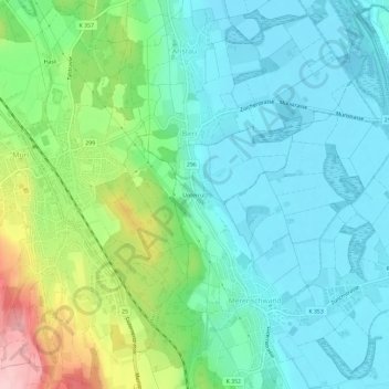
Name: Unterrüti topographic map, elevation, terrain.
Location: Unterrüti, Merenschwand, Bezirk Muri, Aargau, 5634, Schweiz (47.25154 8.34420 47.29154 8.38420)
Average elevation: 430 m
Minimum elevation: 379 m
Maximum elevation: 576 m
Thank you for supporting this site ❤️
Make a donation
Make a donation