
Thank you for supporting this site ❤️
Make a donation
Make a donation
Rome topographic map
Click on the map to display elevation.
Thank you for supporting this site ❤️
Make a donation
Make a donation
About this map
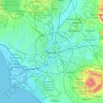
Name: Rome topographic map, elevation, terrain.
Location: Rome, Roma Capitale, Lazio, Italy (41.65564 12.23447 42.14103 12.85576)
Average elevation: 123 m
Minimum elevation: -3 m
Maximum elevation: 1,244 m
Thank you for supporting this site ❤️
Make a donation
Make a donation
Other topographic maps
Click on a map to view its topography, its elevation and its terrain.