Geolocate

Modiin-Maccabim-Reut topographic map

Click on the map to display elevation.

Modiin-Maccabim-Reut

הנחלים HaNechalim – The Rivers (Safdie) and משואה Masuah – Beacon (Givat C) are located towards the west of the city, and were planned by architect Moshe Safdie. Located in these neighborhoods are five commercial centers, a secondary school and three primary schools. The central street names are named after valleys in Israel, and the side streets are named after Israeli rivers and streets. The name "Masuah" was selected in order to represent the neighborhood's high altitude. Within the area consisting of the streets named after rivers and streams is the "Malibu" area, which, as with other areas, is colloquially named after the contractor who designed the neighborhood.

Wikipedia (CC-BY-SA 3.0)

About this map

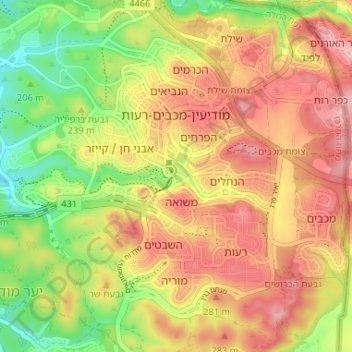
Name: Modiin-Maccabim-Reut topographic map, elevation, terrain.

Location: Modiin-Maccabim-Reut, Ramla Subdistrict, Center District, Israel (31.87669 34.97379 31.92100 35.03905)

Average elevation: 240 m

Minimum elevation: 147 m

Maximum elevation: 320 m

Other topographic maps

Click on a map to view its topography, its elevation and its terrain.

Ramla

Israel > Center District

Average elevation: 75 m

Lod

Israel > Center District

Average elevation: 59 m

Hod HaSharon

Israel > Center District

Average elevation: 38 m

Raanana

Israel > Center District

Average elevation: 49 m

Rosh HaAyin

Israel > Center District

Average elevation: 69 m

Ganei Tikva

Israel > Center District

Average elevation: 68 m

Rosh HaAyin

Israel > Center District

Average elevation: 69 m

Netanya

Israel > Center District

Average elevation: 20 m

Kfar Saba

Israel > Center District

Average elevation: 50 m

Tel Mond

Israel > Center District

Average elevation: 58 m

Kadima - Zoran

Israel > Center District

Average elevation: 51 m

Gedera

Israel > Center District

Average elevation: 56 m

Modiin-Maccabim-Reut

Israel > Center District

הנחלים HaNechalim – The Rivers (Safdie) and משואה Masuah – Beacon (Givat C) are located towards the west of the city, and were planned by architect Moshe Safdie. Located in these neighborhoods are five commercial centers, a secondary school and three primary schools. The central street names are…

Average elevation: 199 m

Raanana

Israel > Center District

Average elevation: 49 m

Lod

Israel > Center District

Average elevation: 59 m

Rishon LeZion

Israel > Center District

Average elevation: 43 m

Gan Yavne

Israel > Center District

Average elevation: 41 m

Modiin-Maccabim-Reut

Israel > Center District

הנחלים HaNechalim – The Rivers (Safdie) and משואה Masuah – Beacon (Givat C) are located towards the west of the city, and were planned by architect Moshe Safdie. Located in these neighborhoods are five commercial centers, a secondary school and three primary schools. The central street names are…

Average elevation: 199 m

Kochav Yair

Israel > Center District

Average elevation: 90 m

Rishon LeZion

Israel > Center District

Average elevation: 33 m

Petah Tikva

Israel > Center District

Average elevation: 37 m

Petah Tikva

Israel > Center District

Average elevation: 37 m

Elad

Israel > Center District

Average elevation: 102 m

Gan Yavne

Israel > Center District

Average elevation: 41 m

Jaljulya

Israel > Center District

Average elevation: 43 m

Kfar Saba

Israel > Center District

Average elevation: 51 m

Shoham

Israel > Center District

Average elevation: 84 m

Savyon

Israel > Center District

Average elevation: 55 m

Rehovot

Israel > Center District

Average elevation: 54 m

Kadima - Zoran

Israel > Center District

Average elevation: 51 m

View point

Israel > Center District > Yavne

Average elevation: 28 m

Kadima - Zoran

Israel > Center District

Average elevation: 51 m

Modiin-Maccabim-Reut

Israel > Center District

הנחלים HaNechalim - The Rivers (Safdie) and משואה Masuah - Beacon (Givat C) are located towards the west of the city, and were planned by architect Moshe Safdie. Located in these neighborhoods are five commercial centers, a secondary school and three primary schools. The central street names are…

Average elevation: 199 m

Petah Tikva

Israel > Center District

Average elevation: 37 m

Raanana

Israel > Center District

Average elevation: 49 m

Lod

Israel > Center District

Average elevation: 59 m

Netanya

Israel > Center District

Average elevation: 20 m

Netanya

Israel > Center District

Average elevation: 15 m

Lod

Israel > Center District

Average elevation: 61 m

Raanana

Israel > Center District

Average elevation: 52 m

Rehovot

Israel > Center District

Average elevation: 49 m

Shoham

Israel > Center District

Average elevation: 101 m

Lod

Israel > Center District

Average elevation: 59 m

Lod

Israel > Center District

Average elevation: 59 m

Netanya

Israel > Center District

Average elevation: 20 m

Rehovot

Israel > Center District

Average elevation: 49 m

Gezer Regional Council

Israel > Center District

Average elevation: 134 m

Yavne

Israel > Center District

Average elevation: 26 m

Kafr Bara

Israel > Center District

Average elevation: 87 m

Netanya

Israel > Center District

Average elevation: 22 m

Marja

Israel > Center District > Zemer > Marja

Average elevation: 96 m

Rishon LeZion

Israel > Center District

Average elevation: 43 m

Gedera

Israel > Center District

Average elevation: 56 m

Petah Tikva

Israel > Center District > Petah Tikva

Average elevation: 83 m

Yavne

Israel > Center District > Yavne

Average elevation: 27 m

Beer Yaakov

Israel > Center District > Beer Yaakov

Average elevation: 67 m

Kfar Saba

Israel > Center District

Average elevation: 51 m

Kfar Saba

Israel > Center District

Average elevation: 51 m

Rishon LeZion

Israel > Center District

Average elevation: 43 m

Hadassim

Israel > Center District > Even Yehuda

Average elevation: 36 m