
Thank you for supporting this site ❤️
Make a donation
Make a donation
Rāmnagar topographic map
Click on the map to display elevation.
Thank you for supporting this site ❤️
Make a donation
Make a donation
Rāmnagar
It has an average elevation of roughly 345 metres (1,132 feet). Ramnagar is located at the foothills of the Himalayas on the bank of river Kosi. The town is visited by many tourists due to its geographical location near Corbett National Park. Its proximity to Nainital which is a famous hill station of Northern India makes it even more popular. There is a Barrage on Kosi River in Ramnagar where many migratory birds such as Ruddy Shelduck arrive in winter.
Thank you for supporting this site ❤️
Make a donation
Make a donation
About this map
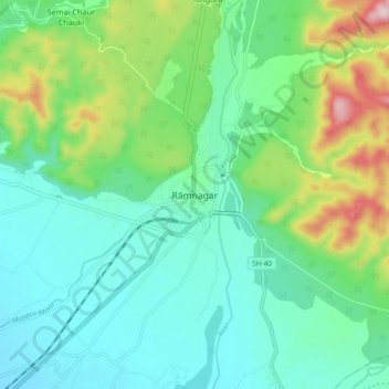
Name: Rāmnagar topographic map, elevation, terrain.
Location: Rāmnagar, Ramnagar, Nainital, Uttarakhand, 244715, India (29.35484 79.08693 29.43484 79.16693)
Average elevation: 391 m
Minimum elevation: 303 m
Maximum elevation: 640 m
Thank you for supporting this site ❤️
Make a donation
Make a donation