
Prachuap Khiri Khan Province topographic map
Interactive map
Click on the map to display elevation.
About this map
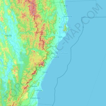
Name: Prachuap Khiri Khan Province topographic map, elevation, terrain.
Location: Prachuap Khiri Khan Province, Thailand (10.94345 99.14342 12.63940 100.23285)
Average elevation: 105 m
Minimum elevation: -1 m
Maximum elevation: 1,281 m
Prachuap Khiri Khan covers an area totaling 6,367 square kilometers (2,458 sq mi). The province is on the Kra Isthmus, the narrow land bridge connecting the Malay Peninsula with mainland Asia. The province has the narrowest part of Thailand, just 12.38 km (7.69 mi) from the Gulf of Thailand to the border with Myanmar in the Tenasserim Hills. Geographically, Prachuap Khiri Khan is a moderate plain with elevations varying from sea level to 1,200 m (3,900 ft). The maximum elevations are found in the northeastern and central west regions, which make up approximately 30 percent of the province. The total forest area is 2,485 km2 (959 sq mi) or 38.7 percent of provincial area.
Other topographic maps
Click on a map to view its topography, its elevation and its terrain.
Choeng Thale
Choeng Thale, Si Sunthon, Phuket Province, 83110, Thailand
Average elevation: 57 m
Ao Hin Khok
Ao Hin Khok, Klaeng Kachet, Rayong Province, 21160, Thailand
Average elevation: 7 m
Ko Tao
Thailand > Surat Thani Province > Ko Tao
Ko Tao, Surat Thani Province, Thailand
Average elevation: 35 m
Khao Sok National Park
Thailand > Surat Thani Province
Khao Sok National Park, Surat Thani Province, 84230, Thailand
Average elevation: 232 m
Hua Hin
Thailand > Prachuap Khiri Khan Province
Hua Hin, Prachuap Khiri Khan Province, 77110, Thailand
Average elevation: 27 m
Nong Bua Lam Phu
Thailand > Nong Bua Lam Phu Province > Nong Bua Lam Phu
Nong Bua Lam Phu, Nong Bua Lam Phu Province, 39000, Thailand
Average elevation: 249 m
Chachoengsao Province
Thailand > Chachoengsao Province
Chachoengsao Province, Thailand
Average elevation: 70 m
Map Ta Phut
Thailand > Rayong Province > Map Ta Phut
Map Ta Phut, Thap Ma, Rayong Province, 21150, Thailand
Average elevation: 24 m
Rayong
Rayong, Choeng Noen, Rayong Province, 21000, Thailand
Average elevation: 31 m
Pak Phanang
Thailand > Nakhon Si Thammarat Province > Pak Phanang
Pak Phanang, Nakhon Si Thammarat Province, Thailand
Average elevation: 3 m