
Thank you for supporting this site ❤️
Make a donation
Make a donation
Postăvaru topographic map
Click on the map to display elevation.
Thank you for supporting this site ❤️
Make a donation
Make a donation
Postăvaru
The Postăvarul massif (Transylvanian German Schuler and Schulerberg, or Hungarian Keresztényhavas) is a massif in Romania; it is part of the Romanian Carpathians, which in turn are part of the Carpathian Mountains range. The altitude of the highest peak, also named Postăvarul is 1799 metres.
Thank you for supporting this site ❤️
Make a donation
Make a donation
About this map
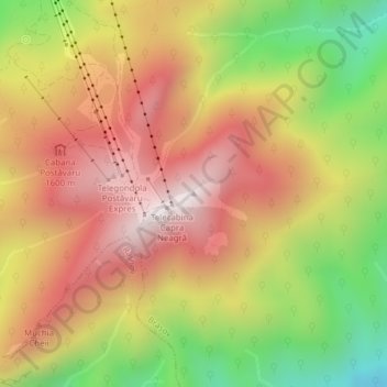
Name: Postăvaru topographic map, elevation, terrain.
Average elevation: 1,362 m
Minimum elevation: 850 m
Maximum elevation: 1,772 m
Thank you for supporting this site ❤️
Make a donation
Make a donation
Other topographic maps
Click on a map to view its topography, its elevation and its terrain.