
Spring topographic map
Click on the map to display elevation.
About this map
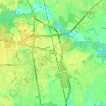
Name: Spring topographic map, elevation, terrain.
Location: Spring, Harris County, Texas, 77373, United States (30.03988 -95.45725 30.11988 -95.37725)
Average elevation: 35 m
Minimum elevation: 23 m
Maximum elevation: 45 m
Other topographic maps
Click on a map to view its topography, its elevation and its terrain.
Houston
United States > Texas > Harris County
Houston is characterized by its predominantly flat topography, sitting at an average elevation of approximately 59 feet (18 meters) above sea level. The city is situated on the Gulf Coastal Plain, which is dissected by a network of bayous that contribute to the region's drainage. This terrain was once covered…
Average elevation: 25 m