
Thank you for supporting this site ❤️
Make a donation
Make a donation
Loghill Village topographic map
Click on the map to display elevation.
Thank you for supporting this site ❤️
Make a donation
Make a donation
About this map
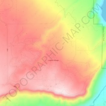
Name: Loghill Village topographic map, elevation, terrain.
Location: Loghill Village, Ouray County, Colorado, United States (38.17638 -107.80423 38.22002 -107.75553)
Average elevation: 2,341 m
Minimum elevation: 2,093 m
Maximum elevation: 2,471 m
Thank you for supporting this site ❤️
Make a donation
Make a donation