
Yongsan-gu topographic map
Interactive map
Click on the map to display elevation.
About this map
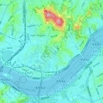
Name: Yongsan-gu topographic map, elevation, terrain.
Location: Yongsan-gu, Seoul, South Korea (37.50647 126.94458 37.55564 127.01752)
Average elevation: 39 m
Minimum elevation: 2 m
Maximum elevation: 265 m
Yongsan is located next to the Han River, with level ground in the west of the district which has been used for transportation (rail) and commercial use since the early 20th century. To the east and north in the land is steeper and rises towards Namsan which lies to the north. Namsan has an elevation of 243m and consists mostly of granite.[2] The low lying western section of the district is approximately 15-20 above sea level. This low-lying area has been prone to flooding during periods of heavy rainfall, a common issue with most of the low lying riverside districts in the city.[3]
Other topographic maps
Click on a map to view its topography, its elevation and its terrain.