
Thank you for supporting this site ❤️
Make a donation
Make a donation
Teresa topographic map
Click on the map to display elevation.
Thank you for supporting this site ❤️
Make a donation
Make a donation
About this map
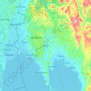
Name: Teresa topographic map, elevation, terrain.
Location: Teresa, Rizal, Calabarzon, 1670, Philippines (14.51889 121.16795 14.59889 121.24795)
Average elevation: 115 m
Minimum elevation: 2 m
Maximum elevation: 272 m
Thank you for supporting this site ❤️
Make a donation
Make a donation
Other topographic maps
Click on a map to view its topography, its elevation and its terrain.
Montalban
Rodriguez is generally very rough in topography, with 83% of its total land area composed of upland areas, hills and mountain ranges. The remaining 17% low-lying terrain and rolling lands are found at the south-western portion of the municipality, along with the northern portions of the Municipality of San…
Average elevation: 230 m