
Thank you for supporting this site ❤️
Make a donation
Make a donation
Banița topographic map
Click on the map to display elevation.
Thank you for supporting this site ❤️
Make a donation
Make a donation
About this map
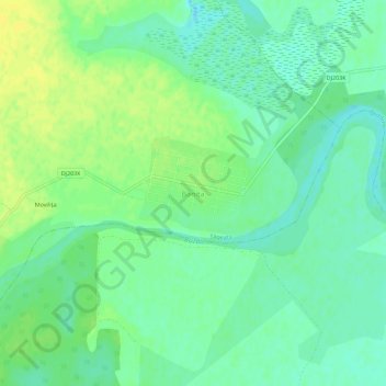
Name: Banița topographic map, elevation, terrain.
Location: Banița, Săgeata, Buzău, 127526, Romania (45.08019 27.08210 45.12019 27.12210)
Average elevation: 57 m
Minimum elevation: 48 m
Maximum elevation: 67 m
Thank you for supporting this site ❤️
Make a donation
Make a donation
Other topographic maps
Click on a map to view its topography, its elevation and its terrain.
Thank you for supporting this site ❤️
Make a donation
Make a donation
Thank you for supporting this site ❤️
Make a donation
Make a donation
Thank you for supporting this site ❤️
Make a donation
Make a donation
Thank you for supporting this site ❤️
Make a donation
Make a donation
Buzău
The city is located in the center of the county, 100 km north-east of Bucharest, in the South-East of Romania, taking up a total area of 81,3 km2, at the outermost curvature of the Subcarpathian foothills, at the crossroads of the three main Romanian historical provinces: Wallachia, Transylvania and Moldavia.…
Average elevation: 96 m
Thank you for supporting this site ❤️
Make a donation
Make a donation