
Auberville topographic map
Interactive map
Click on the map to display elevation.
About this map
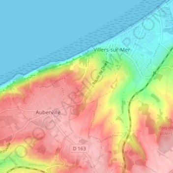
Name: Auberville topographic map, elevation, terrain.
Average elevation: 61 m
Minimum elevation: 0 m
Maximum elevation: 136 m
Other topographic maps
Click on a map to view its topography, its elevation and its terrain.
Hammeau Goblin
France > Normandie > Calvados > Villers-sur-Mer
Hammeau Goblin, Villers-sur-Mer, Lisieux, Calvados, Normandie, France métropolitaine, 14640, France
Average elevation: 15 m
Les Champs Rabats
France > Normandie > Calvados > Villers-sur-Mer
Les Champs Rabats, Villers-sur-Mer, Lisieux, Calvados, Normandie, France métropolitaine, 14640, France
Average elevation: 41 m