
Make a donation
Dörrenzimmern topographic map
Click on the map to display elevation.
Make a donation
About this map
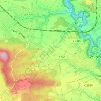
Name: Dörrenzimmern topographic map, elevation, terrain.
Average elevation: 399 m
Minimum elevation: 316 m
Maximum elevation: 507 m
Make a donation
Other topographic maps
Click on a map to view its topography, its elevation and its terrain.
74523
Deutschland > Baden-Württemberg > Landkreis Schwäbisch Hall > Schwäbisch Hall > Hessental
Average elevation: 405 m
Tüngental
Deutschland > Baden-Württemberg > Landkreis Schwäbisch Hall > Schwäbisch Hall
Average elevation: 391 m
74523
Deutschland > Baden-Württemberg > Landkreis Schwäbisch Hall > Schwäbisch Hall > Hessental
Average elevation: 405 m
Gelbingen
Deutschland > Baden-Württemberg > Landkreis Schwäbisch Hall > Schwäbisch Hall
Average elevation: 347 m
Make a donation
Gailenkirchen
Deutschland > Baden-Württemberg > Landkreis Schwäbisch Hall > Schwäbisch Hall
Average elevation: 398 m