
Make a donation
Bața topographic map
Click on the map to display elevation.
Make a donation
About this map
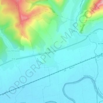
Name: Bața topographic map, elevation, terrain.
Location: Bața, Petru Rareș, Bistrița-Năsăud, 427216, Romania (47.16845 23.97446 47.20845 24.01446)
Average elevation: 270 m
Minimum elevation: 235 m
Maximum elevation: 414 m
Make a donation
Other topographic maps
Click on a map to view its topography, its elevation and its terrain.
Bistrița
According to Köppen climate classification, Bistrița has a humid continental climate(Dfb) with cold, snowy winters and warm, rainy summers. Due to its modest elevation, Bistrița has one of the coldest climates in Romania.
Average elevation: 429 m
Make a donation
Make a donation
Bistrița
Due to its modest elevation, Bistrița has one of the coldest climates in Romania.
Average elevation: 429 m
Bistrița
According to Köppen climate classification, Bistrița has a humid continental climate(Dfb) with cold, snowy winters and warm, rainy summers. Due to its modest elevation, Bistrița has one of the coldest climates in Romania.
Average elevation: 429 m
Make a donation
Make a donation