
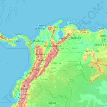
Colombia topographic map
Interactive map
Click on the map to display elevation.
About this map
Name: Colombia topographic map, elevation, terrain.
Location: Colombia (-4.22940 -82.12436 16.04955 -66.84904)
Average elevation: 248 m
Minimum elevation: -2 m
Maximum elevation: 5,809 m
Mountain climate is one of the unique features of the Andes and other high altitude reliefs where climate is determined by elevation. Below 1,000 meters (3,281 ft) in elevation is the warm altitudinal zone, where temperatures are above 24 °C (75.2 °F). About 82.5% of the country's total area lies in the warm altitudinal zone. The temperate climate altitudinal zone located between 1,001 and 2,000 meters (3,284 and 6,562 ft) is characterized for presenting an average temperature ranging between 17 and 24 °C (62.6 and 75.2 °F). The cold climate is present between 2,001 and 3,000 meters (6,565 and 9,843 ft) and the temperatures vary between 12 and 17 °C (53.6 and 62.6 °F). Beyond lies the alpine conditions of the forested zone and then the treeless grasslands of the páramos. Above 4,000 meters (13,123 ft), where temperatures are below freezing, the climate is glacial, a zone of permanent snow and ice.
Other topographic maps
Click on a map to view its topography, its elevation and its terrain.
Bikaner
India > Rajasthan > Bikaner Tehsil
Bikaner, Bikaner Tehsil, Bikaner District, Rajasthan, 334001, India
Average elevation: 225 m
Liberty Township
United States > Ohio > Butler County
Liberty Township, Butler County, Ohio, United States
Average elevation: 233 m
Iran
Iran
Average elevation: 786 m
Viljoenskroon
South Africa > Free State > Fezile Dabi District Municipality > Moqhaka Local Municipality
Viljoenskroon, Moqhaka Local Municipality, Fezile Dabi District Municipality, Free State, South Africa
Average elevation: 1,335 m
Gokyo Ri
Nepal > Koshi Province > Solukhumbu
Gokyo Ri, Khumbupasanglahmu, Solukhumbu, Koshi Province, Nepal
Average elevation: 4,968 m
Kyrgyzstan
Kyrgyzstan
Average elevation: 1,973 m
Gualeguaychu
Argentina > Entre Ríos Province > Distrito Costa Uruguay Sur
Gualeguaychu, Gualeguaychú, Distrito Costa Uruguay Sur, Departamento Gualeguaychú, Entre Ríos Province, Argentina
Average elevation: 12 m
Nepal
Nepal
Average elevation: 2,591 m
Lubbock
United States > Texas > Lubbock County
Lubbock, Lubbock County, Texas, United States
Average elevation: 983 m
Germany
Germany
Average elevation: 237 m
Elbląg
Poland > Warmian-Masurian Voivodeship > Elbląg County > Elbląg
Elbląg, gmina Elbląg, Elbląg County, Warmian-Masurian Voivodeship, Poland
Average elevation: 36 m
Campton Township
United States > Illinois > Kane County
Campton Township, Kane County, Illinois, United States
Average elevation: 267 m
Tameslouht
Morocco > Cercle de Tahannaout دائرة تحناوت
Tameslouht, caïdat de Tameslouhte, Cercle de Tahannaout دائرة تحناوت, Al Haouz Province, Marrakech-Safi, 42312, Morocco
Average elevation: 627 m
Myślęcin
Poland > Warmian-Masurian Voivodeship > Elbląg County
Myślęcin, gmina Elbląg, Elbląg County, Warmian-Masurian Voivodeship, Poland
Average elevation: 33 m
Steventon
United Kingdom > England > Hampshire > Basingstoke and Deane
Steventon, Basingstoke and Deane, Hampshire, England, United Kingdom
Average elevation: 134 m
Hadera
Hadera, Hadera Subdistrict, Haifa District, Israel
Average elevation: 20 m
Sheffield
Sheffield, South Yorkshire, England, United Kingdom
Average elevation: 168 m
Emek Izrael Regional Council
Emek Izrael Regional Council, Jezreel Subdistrict, North District, 3657700, Israel
Average elevation: 158 m
Rila mountain range
Rila mountain range, Samokov, Sofia, Bulgaria
Average elevation: 2,525 m
Haddon Hill
Sri Lanka > Central Province > Nuwara Eliya
Haddon Hill, Nuwara Eliya, Nuwara Eliya District, Central Province, 22200, Sri Lanka
Average elevation: 1,968 m
Chester
United Kingdom > England > Cheshire West and Chester
Chester, Cheshire West and Chester, England, CH1 2ET, United Kingdom
Average elevation: 61 m
Dijon
France > Bourgogne-Franche-Comté > Côte-d'Or
Dijon, Côte-d'Or, Bourgogne-Franche-Comté, Metropolitan France, 21000, France
Average elevation: 275 m
Marystown
Canada > Newfoundland and Labrador
Marystown, Newfoundland, Newfoundland and Labrador, A0E 2M0, Canada
Average elevation: 52 m
Loriol-sur-Drôme
France > Auvergne-Rhône-Alpes > Drôme
Loriol-sur-Drôme, Die, Drôme, Auvergne-Rhône-Alpes, Metropolitan France, 26270, France
Average elevation: 158 m
Mercury
United States > Nevada > Nye County
Mercury, Nye County, Nevada, 89023, United States
Average elevation: 1,183 m
Grantsburg
United States > Illinois > Johnson County
Grantsburg, Johnson County, Illinois, 62943, United States
Average elevation: 121 m
Kaddarim
Israel > North District > Galil Elyon Regional Council
Kaddarim, Galil Elyon Regional Council, Safed Subdistrict, North District, Israel
Average elevation: 78 m
Louisville
United States > Kentucky > Jefferson County
Louisville, Jefferson County, Kentucky, United States
Average elevation: 188 m
Hod HaSharon
Hod HaSharon, Petah Tikva Subdistrict, Center District, Israel
Average elevation: 41 m
Rehovot
Rehovot, Rehovot Subdistrict, Center District, Israel
Average elevation: 54 m
Odolenovice u Jenišovic
Czechia > Northeast > Liberecký kraj
Odolenovice u Jenišovic, Jenišovice, okres Jablonec nad Nisou, Liberecký kraj, Northeast, Czechia
Average elevation: 418 m
Cima Pissola
Italy > Trentino-Alto Adige/Südtirol > Provincia di Trento
Cima Pissola, Borgo Chiese, Comunità delle Giudicarie, Provincia di Trento, Trentino-Alto Adige/Südtirol, 38083, Italy
Average elevation: 1,713 m
Harlingen
United States > Texas > Cameron County
Harlingen, Cameron County, Texas, 78550, United States
Average elevation: 14 m
Aiken County
United States > South Carolina
Aiken County, South Carolina, United States
Average elevation: 109 m
Imatra
Imatra, Imatra sub-region, South Karelia, Southern Finland, Mainland Finland, Finland
Average elevation: 75 m
Adanim
Israel > Center District > Drom HaSharon Regional Council
Adanim, Drom HaSharon Regional Council, Petah Tikva Subdistrict, Center District, Israel
Average elevation: 25 m