
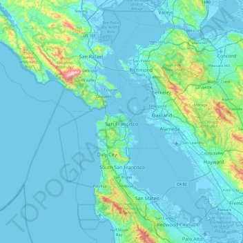
San Francisco topographic map
Interactive map
Click on the map to display elevation.
About this map
Name: San Francisco topographic map, elevation, terrain.
Average elevation: 63 m
Minimum elevation: -6 m
Maximum elevation: 753 m
Other topographic maps
Click on a map to view its topography, its elevation and its terrain.
Cobb
United States > California > Lake County
Cobb is a census designated place (CDP) in Lake County, California, United States. Cobb is located 1 mile (1.6 km) northwest of Whispering Pines, at an elevation of 2,631 feet (802 m). The population was 1,778 at the 2010 census, up from 1,638 at the 2000 census.
Average elevation: 887 m
Bombay Beach
The derelict "living ghost town" status of Bombay Beach has attracted many photographers, filmmakers, urban explorers, and tourists, to the point that locals tend to ask visitors if they are filmmakers that are there to shoot a documentary. The town, as well as others on the shores of the Salton Sea, is one of…
Average elevation: -61 m