
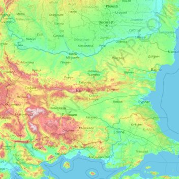
Bulgaria topographic map
Interactive map
Click on the map to display elevation.
About this map
Name: Bulgaria topographic map, elevation, terrain.
Location: Bulgaria (41.23537 22.35715 44.21565 28.88754)
Average elevation: 300 m
Minimum elevation: -3 m
Maximum elevation: 2,750 m
Bulgaria is a small country situated in Southeastern Europe, in the east of the Balkans. Its territory covers an area of 110,994 square kilometres (42,855 sq mi), while land borders with its five neighbouring countries run a total length of 1,808 kilometres (1,123 mi), and its coastline is 354 kilometres (220 mi) long. Bulgaria's geographic coordinates are 43° N 25° E. The most notable topographical features of the country are the Danubian Plain, the Balkan Mountains, the Thracian Plain, and the Rila-Rhodope massif. The southern edge of the Danubian Plain slopes upward into the foothills of the Balkans, while the Danube defines the border with Romania. The Thracian Plain is roughly triangular, beginning southeast of Sofia and broadening as it reaches the Black Sea coast.
Other topographic maps
Click on a map to view its topography, its elevation and its terrain.
Bikaner
India > Rajasthan > Bikaner Tehsil
Bikaner, Bikaner Tehsil, Bikaner District, Rajasthan, 334001, India
Average elevation: 225 m
Liberty Township
United States > Ohio > Butler County
Liberty Township, Butler County, Ohio, United States
Average elevation: 233 m
Iran
Iran
Average elevation: 786 m
Viljoenskroon
South Africa > Free State > Fezile Dabi District Municipality > Moqhaka Local Municipality
Viljoenskroon, Moqhaka Local Municipality, Fezile Dabi District Municipality, Free State, South Africa
Average elevation: 1,335 m
Gokyo Ri
Nepal > Koshi Province > Solukhumbu
Gokyo Ri, Khumbupasanglahmu, Solukhumbu, Koshi Province, Nepal
Average elevation: 4,968 m
Kyrgyzstan
Kyrgyzstan
Average elevation: 1,973 m
Gualeguaychu
Argentina > Entre Ríos Province > Distrito Costa Uruguay Sur
Gualeguaychu, Gualeguaychú, Distrito Costa Uruguay Sur, Departamento Gualeguaychú, Entre Ríos Province, Argentina
Average elevation: 12 m
Nepal
Nepal
Average elevation: 2,591 m
Lubbock
United States > Texas > Lubbock County
Lubbock, Lubbock County, Texas, United States
Average elevation: 983 m
Germany
Germany
Average elevation: 237 m
Elbląg
Poland > Warmian-Masurian Voivodeship > Elbląg County > Elbląg
Elbląg, gmina Elbląg, Elbląg County, Warmian-Masurian Voivodeship, Poland
Average elevation: 36 m
Campton Township
United States > Illinois > Kane County
Campton Township, Kane County, Illinois, United States
Average elevation: 267 m
Tameslouht
Morocco > Cercle de Tahannaout دائرة تحناوت
Tameslouht, caïdat de Tameslouhte, Cercle de Tahannaout دائرة تحناوت, Al Haouz Province, Marrakech-Safi, 42312, Morocco
Average elevation: 627 m
Myślęcin
Poland > Warmian-Masurian Voivodeship > Elbląg County
Myślęcin, gmina Elbląg, Elbląg County, Warmian-Masurian Voivodeship, Poland
Average elevation: 33 m
Steventon
United Kingdom > England > Hampshire > Basingstoke and Deane
Steventon, Basingstoke and Deane, Hampshire, England, United Kingdom
Average elevation: 134 m
Hadera
Hadera, Hadera Subdistrict, Haifa District, Israel
Average elevation: 20 m
Sheffield
Sheffield, South Yorkshire, England, United Kingdom
Average elevation: 168 m
Emek Izrael Regional Council
Emek Izrael Regional Council, Jezreel Subdistrict, North District, 3657700, Israel
Average elevation: 158 m
Rila mountain range
Rila mountain range, Samokov, Sofia, Bulgaria
Average elevation: 2,525 m
Haddon Hill
Sri Lanka > Central Province > Nuwara Eliya
Haddon Hill, Nuwara Eliya, Nuwara Eliya District, Central Province, 22200, Sri Lanka
Average elevation: 1,968 m
Chester
United Kingdom > England > Cheshire West and Chester
Chester, Cheshire West and Chester, England, CH1 2ET, United Kingdom
Average elevation: 61 m
Dijon
France > Bourgogne-Franche-Comté > Côte-d'Or
Dijon, Côte-d'Or, Bourgogne-Franche-Comté, Metropolitan France, 21000, France
Average elevation: 275 m
Marystown
Canada > Newfoundland and Labrador
Marystown, Newfoundland, Newfoundland and Labrador, A0E 2M0, Canada
Average elevation: 52 m
Loriol-sur-Drôme
France > Auvergne-Rhône-Alpes > Drôme
Loriol-sur-Drôme, Die, Drôme, Auvergne-Rhône-Alpes, Metropolitan France, 26270, France
Average elevation: 158 m
Mercury
United States > Nevada > Nye County
Mercury, Nye County, Nevada, 89023, United States
Average elevation: 1,183 m
Grantsburg
United States > Illinois > Johnson County
Grantsburg, Johnson County, Illinois, 62943, United States
Average elevation: 121 m
Kaddarim
Israel > North District > Galil Elyon Regional Council
Kaddarim, Galil Elyon Regional Council, Safed Subdistrict, North District, Israel
Average elevation: 78 m
Louisville
United States > Kentucky > Jefferson County
Louisville, Jefferson County, Kentucky, United States
Average elevation: 188 m
Hod HaSharon
Hod HaSharon, Petah Tikva Subdistrict, Center District, Israel
Average elevation: 41 m
Rehovot
Rehovot, Rehovot Subdistrict, Center District, Israel
Average elevation: 54 m
Odolenovice u Jenišovic
Czechia > Northeast > Liberecký kraj
Odolenovice u Jenišovic, Jenišovice, okres Jablonec nad Nisou, Liberecký kraj, Northeast, Czechia
Average elevation: 418 m
Cima Pissola
Italy > Trentino-Alto Adige/Südtirol > Provincia di Trento
Cima Pissola, Borgo Chiese, Comunità delle Giudicarie, Provincia di Trento, Trentino-Alto Adige/Südtirol, 38083, Italy
Average elevation: 1,713 m
Harlingen
United States > Texas > Cameron County
Harlingen, Cameron County, Texas, 78550, United States
Average elevation: 14 m
Aiken County
United States > South Carolina
Aiken County, South Carolina, United States
Average elevation: 109 m
Imatra
Imatra, Imatra sub-region, South Karelia, Southern Finland, Mainland Finland, Finland
Average elevation: 75 m
Adanim
Israel > Center District > Drom HaSharon Regional Council
Adanim, Drom HaSharon Regional Council, Petah Tikva Subdistrict, Center District, Israel
Average elevation: 25 m