
South Africa topographic map
Interactive map
Click on the map to display elevation.
South Africa
South Africa's topography is characterized by a high central plateau, known as the Highveld, which lies at elevations between 1,200 and 1,800 meters (3,937 to 5,906 feet) above sea level. This plateau is encircled by the Great Escarpment, a prominent mountainous feature that includes the Drakensberg Mountains, where peaks can reach up to 3,482 meters (11,424 feet). Descending from the escarpment, the terrain transitions into narrow coastal plains along both the Atlantic and Indian Oceans. In the southwest, the landscape is further defined by the Cape Fold Mountains, a series of parallel ranges with peaks exceeding 2,000 meters (6,562 feet). Between these mountain ranges and the central plateau lie arid regions such as the Great Karoo and the Little Karoo, characterized by semi-desert conditions and unique geological formations. This diverse terrain supports a wide range of ecosystems, from grasslands and savannas to forests and deserts.
About this map
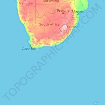
Name: South Africa topographic map, elevation, terrain.
Location: South Africa (-47.17883 16.33352 -22.12503 38.28990)
Average elevation: 221 m
Minimum elevation: 0 m
Maximum elevation: 3,367 m
Other topographic maps
Click on a map to view its topography, its elevation and its terrain.
Viljoenskroon
South Africa > Free State > Fezile Dabi District Municipality > Moqhaka Local Municipality
Average elevation: 1,335 m
Lusikisiki
South Africa > Eastern Cape > Ingquza Hill Local Municipality > Lusikisiki
Average elevation: 563 m
Whale viewing site
South Africa > Western Cape > Overberg District Municipality > Overstrand Local Municipality > Gansbaai
Average elevation: 22 m