
Mioarele topographic map
Interactive map
Click on the map to display elevation.
About this map
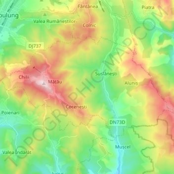
Name: Mioarele topographic map, elevation, terrain.
Location: Mioarele, Argeș, Romania (45.20617 25.04296 45.25873 25.17073)
Average elevation: 715 m
Minimum elevation: 533 m
Maximum elevation: 1,011 m
Other topographic maps
Click on a map to view its topography, its elevation and its terrain.