
Bolivia topographic map
Interactive map
Click on the map to display elevation.
Bolivia
The geography of the country exhibits a great variety of terrain and climates. Bolivia has a high level of biodiversity, considered one of the greatest in the world, as well as several ecoregions with ecological sub-units such as the Altiplano, tropical rainforests (including Amazon rainforest), dry valleys, and the Chiquitania, which is a tropical savanna. These areas feature enormous variations in altitude, from an elevation of 6,542 meters (21,463 ft) above sea level in Nevado Sajama to nearly 70 meters (230 ft) along the Paraguay River. Although a country of great geographic diversity, Bolivia has remained a landlocked country since the War of the Pacific. Puerto Suárez, San Matías and Puerto Quijarro are located in the Bolivian Pantanal.
About this map
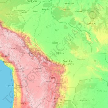
Name: Bolivia topographic map, elevation, terrain.
Location: Bolivia (-22.89827 -69.64501 -9.66894 -57.45300)
Average elevation: 1,136 m
Minimum elevation: 0 m
Maximum elevation: 6,250 m
Other topographic maps
Click on a map to view its topography, its elevation and its terrain.