
United Arab Emirates topographic map
Interactive map
Click on the map to display elevation.
United Arab Emirates
The climate of the UAE is subtropical-arid with hot summers and warm winters. The climate is categorized as desert climate. The hottest months are July and August, when average maximum temperatures reach above 45 °C (113 °F) on the coastal plain. In the Al Hajar Mountains, temperatures are considerably lower, a result of increased elevation. Average minimum temperatures in January and February are between 10 and 14 °C (50 and 57 °F). During the late summer months, a humid southeastern wind known as Sharqi (i.e. "Easterner") makes the coastal region especially unpleasant. The average annual rainfall in the coastal area is less than 120 mm (4.7 in), but in some mountainous areas annual rainfall often reaches 350 mm (13.8 in). Rain in the coastal region falls in short, torrential bursts during the summer months, sometimes resulting in floods in ordinarily dry wadi beds. The region is prone to occasional, violent dust storms, which can severely reduce visibility.
About this map
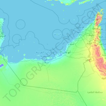
Name: United Arab Emirates topographic map, elevation, terrain.
Location: United Arab Emirates (22.63162 51.41607 26.15172 56.60245)
Average elevation: 85 m
Minimum elevation: -15 m
Maximum elevation: 2,000 m
Other topographic maps
Click on a map to view its topography, its elevation and its terrain.