
Make a donation
Kurdistan Province topographic map
Click on the map to display elevation.
Make a donation
About this map
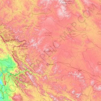
Name: Kurdistan Province topographic map, elevation, terrain.
Location: Kurdistan Province, Iran (34.73657 45.55765 36.45960 48.29018)
Average elevation: 1,754 m
Minimum elevation: 374 m
Maximum elevation: 3,287 m
Make a donation
Other topographic maps
Click on a map to view its topography, its elevation and its terrain.
Natanz
Iran > Isfahan Province > Natanz County > دهستان کرکس
Natanz is located 120 km northeast of Isfahan and on the main north-south highway of Iran. Its altitude is 1666 meters above sea level. The distance between Tehran and Natanz is 326 km, and it takes about 4 hours by car. The Karkas mountain chain (Kuh-e Karkas) (meaning mountain of vultures), at an elevation…
Average elevation: 1,775 m
Make a donation
Sinabad
Iran > West Azerbaijan Province > Urumia County > دهستان صومای جنوبی
Average elevation: 1,876 m
Make a donation
Make a donation
Make a donation
Karimabad
Iran > West Azerbaijan Province > Urumia County > دهستان نازلوشمالی
Average elevation: 1,327 m
Make a donation
Mozdooran Cave
Iran > Razavi Khorasan > Sarakhs County > دهستان مرزداران > Mazdavand
Average elevation: 976 m
Make a donation
عزیزآباد پایین
Iran > Sistan and Baluchestan Province > Konarak County > دهستان تنگ
Average elevation: 9 m
Make a donation
Kermanshah
The province's capital is Kermanshah, located in the middle of the western part of Iran. The population of the city is 946,651 as of 2016. It is built on the slopes of Mt. Sefid Kooh and extended toward south during last two decades. The built-up areas run alongside Sarab River and Sarab Valley. The city's…
Average elevation: 1,054 m
Make a donation
Band-e Amir
Iran > Fars Province > Zarghan County > Band-e Amir Rural District
Average elevation: 1,598 m
Make a donation
Make a donation
Pardisan Park
Iran > Sistan and Baluchestan Province > Zahedan County > Zahedan
Average elevation: 1,400 m
Make a donation
Make a donation
Manj
Iran > Chaharmahal and Bakhtiyari Province > Lordegan County > Manj village
Average elevation: 1,634 m
Make a donation
Make a donation
Zagros Mountains
Iran > Isfahan Province > Semirom County > Padena-ye Vosta RD
Average elevation: 3,846 m
Anbar sar
Iran > Gilan Province > Astaneh-ye Ashrafiyeh County > دهستان دهگاه
Average elevation: -25 m
Anbar sar
Iran > Gilan Province > Astaneh-ye Ashrafiyeh County > دهستان دهگاه
Average elevation: -25 m
Suran
Iran > Sistan and Baluchestan Province > Sib and Suran County > دهستان سیب وسوران
Average elevation: 1,157 m
Make a donation
Anbar sar
Iran > Gilan Province > Astaneh-ye Ashrafiyeh County > دهستان دهگاه
Average elevation: -25 m
Make a donation
Make a donation
Khalifan, Mahabad
Iran > West Azerbaijan Province > Mahabad County > دهستان کانی بازار
Average elevation: 1,558 m
Make a donation
Badaki
Iran > West Azerbaijan Province > Chaypareh County > دهستان قره ضیاءالدین
Average elevation: 1,169 m
Make a donation
Kelardasht
Iran > Mazandaran Province > Kelardasht County > دهستان کلاردشت غربی
Average elevation: 1,473 m
Make a donation
Make a donation
Damavand
Iran > Mazandaran Province > Amol County > دهستان لاریجان سفلی
Mount Damavand (Persian: دماوند [dæmɒːvænd] ) is a dormant stratovolcano and is the highest peak in Iran and Western Asia, the highest volcano in Asia, and the 3rd highest volcano in the Eastern Hemisphere (after Mount Kilimanjaro and Mount Elbrus), at an elevation of 5,609 metres (18,402 ft).…
Average elevation: 4,949 m
Alborz Mountains
Iran > Mazandaran Province > Amol County > دهستان لاریجان سفلی
While the southern slopes of the Alborz Mountains are usually semiarid or arid, with irregular and low precipitation, the northern slopes of the range are usually humid, especially in the western parts of the Central Alborz. The Alborz is the easternmost extent of many European plant species. In the southern…
Average elevation: 4,934 m
Make a donation
Make a donation
Make a donation