
La Paz topographic map
Interactive map
Click on the map to display elevation.
La Paz
The city, in west-central Bolivia 68 km (42 mi) southeast of Lake Titicaca, is set in a canyon created by the Choqueyapu River. It is in a bowl-like depression, part of the Amazon basin, surrounded by the high mountains of the Altiplano. Overlooking the city is the towering, triple-peaked Illimani. Its peaks are always snow-covered and can be seen from many parts of the city. At an elevation of roughly 3,650 m (11,975 ft) above sea level, La Paz is the highest capital city in the world. Due to its altitude, La Paz has an unusual subtropical highland climate, with rainy summers and dry winters.
About this map
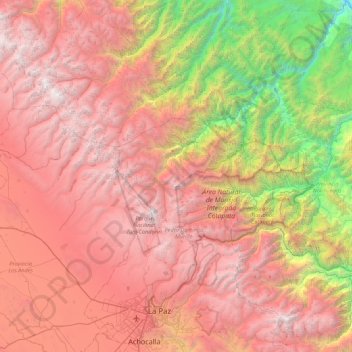
Name: La Paz topographic map, elevation, terrain.
Location: La Paz, Pedro Domingo Murillo, La Paz, Bolivia (-16.59231 -68.24585 -15.75864 -67.62371)
Average elevation: 3,544 m
Minimum elevation: 696 m
Maximum elevation: 6,381 m
Other topographic maps
Click on a map to view its topography, its elevation and its terrain.
La Paz
Bolivia > La Paz > Pedro Domingo Murillo > La Paz
The city, in west-central Bolivia 68 km (42 mi) southeast of Lake Titicaca, is set in a canyon created by the Choqueyapu River. It is in a bowl-like depression, part of the Amazon basin, surrounded by the high mountains of the Altiplano. Overlooking the city is the towering, triple-peaked Illimani. Its peaks…
Average elevation: 4,087 m