
Ticino topographic map
Interactive map
Click on the map to display elevation.
Ticino
Although it includes the lowest point of Switzerland (Lake Maggiore) as well as its lowest town (Ascona), the topography of Ticino is extremely rugged, as it is the fourth canton with the biggest elevation difference. It lies essentially within the Alps, in particular the Lepontine Alps, the Saint-Gotthard Massif and the Lugano Prealps. The longest and deepest valleys are those of the Ticino, Verzasca and Maggia. The two highest mountains are the Rheinwaldhorn and the Basòdino. Other notable mountains are Pizzo Rotondo (highest of the Gotthard Massif), Pizzo Campo Tencia (highest fully within the canton), Monte Generoso (highest south of Lake Lugano) and Monte Tamaro (most prominent of the canton). For an exhausitve list, see list of mountains of Ticino.
About this map
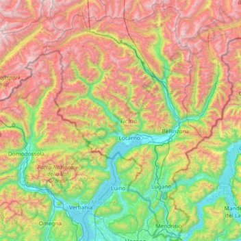
Name: Ticino topographic map, elevation, terrain.
Location: Ticino, Switzerland (45.81800 8.38204 46.63249 9.15970)
Average elevation: 1,389 m
Minimum elevation: 187 m
Maximum elevation: 3,546 m