
Váh topographic map
Interactive map
Click on the map to display elevation.
About this map
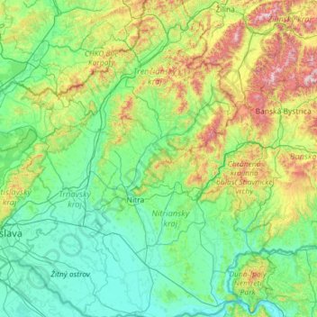
Name: Váh topographic map, elevation, terrain.
Location: Váh, Western Slovakia, 014 01, Slovakia (47.74679 17.73789 49.26179 19.80875)
Average elevation: 347 m
Minimum elevation: 101 m
Maximum elevation: 1,696 m
Other topographic maps
Click on a map to view its topography, its elevation and its terrain.
Senec
Slovakia > Region of Bratislava > District of Senec > Senec
Senec, District of Senec, Region of Bratislava, 90301, Slovakia
Average elevation: 138 m
Chyžné
Slovakia > Region of Banská Bystrica > District of Revúca > Chyžné
Chyžné, District of Revúca, Region of Banská Bystrica, Central Slovakia, 049 18, Slovakia
Average elevation: 343 m
Jablonka
Slovakia > Region of Trenčín > District of Myjava > Jablonka
Jablonka, District of Myjava, Region of Trenčín, Western Slovakia, 906 21, Slovakia
Average elevation: 362 m