
Egypt topographic map
Interactive map
Click on the map to display elevation.
About this map
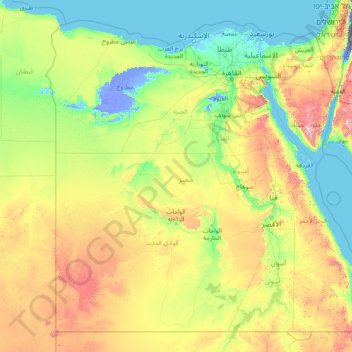
Name: Egypt topographic map, elevation, terrain.
Location: Egypt (21.99367 24.64991 31.83309 37.11535)
Average elevation: 272 m
Minimum elevation: -415 m
Maximum elevation: 2,442 m
Other topographic maps
Click on a map to view its topography, its elevation and its terrain.
Bikaner
India > Rajasthan > Bikaner Tehsil
Bikaner, Bikaner Tehsil, Bikaner District, Rajasthan, 334001, India
Average elevation: 225 m
Liberty Township
United States > Ohio > Butler County
Liberty Township, Butler County, Ohio, United States
Average elevation: 233 m
Iran
Iran
Average elevation: 786 m
Viljoenskroon
South Africa > Free State > Fezile Dabi District Municipality > Moqhaka Local Municipality
Viljoenskroon, Moqhaka Local Municipality, Fezile Dabi District Municipality, Free State, South Africa
Average elevation: 1,335 m
Gokyo Ri
Nepal > Koshi Province > Solukhumbu
Gokyo Ri, Khumbupasanglahmu, Solukhumbu, Koshi Province, Nepal
Average elevation: 4,968 m
Kyrgyzstan
Kyrgyzstan
Average elevation: 1,973 m
Gualeguaychu
Argentina > Entre Ríos Province > Distrito Costa Uruguay Sur
Gualeguaychu, Gualeguaychú, Distrito Costa Uruguay Sur, Departamento Gualeguaychú, Entre Ríos Province, Argentina
Average elevation: 12 m
Lubbock
United States > Texas > Lubbock County
Lubbock, Lubbock County, Texas, United States
Average elevation: 983 m
Nepal
Nepal
Average elevation: 2,591 m
Germany
Germany
Average elevation: 237 m
Elbląg
Poland > Warmian-Masurian Voivodeship > Elbląg County > Elbląg
Elbląg, gmina Elbląg, Elbląg County, Warmian-Masurian Voivodeship, Poland
Average elevation: 36 m
Campton Township
United States > Illinois > Kane County
Campton Township, Kane County, Illinois, United States
Average elevation: 267 m
Tameslouht
Morocco > Cercle de Tahannaout دائرة تحناوت
Tameslouht, caïdat de Tameslouhte, Cercle de Tahannaout دائرة تحناوت, Al Haouz Province, Marrakech-Safi, 42312, Morocco
Average elevation: 627 m
Myślęcin
Poland > Warmian-Masurian Voivodeship > Elbląg County
Myślęcin, gmina Elbląg, Elbląg County, Warmian-Masurian Voivodeship, Poland
Average elevation: 33 m
Steventon
United Kingdom > England > Hampshire > Basingstoke and Deane
Steventon, Basingstoke and Deane, Hampshire, England, United Kingdom
Average elevation: 134 m
Hadera
Hadera, Hadera Subdistrict, Haifa District, Israel
Average elevation: 20 m
Sheffield
Sheffield, South Yorkshire, England, United Kingdom
Average elevation: 168 m
Emek Izrael Regional Council
Emek Izrael Regional Council, Jezreel Subdistrict, North District, 3657700, Israel
Average elevation: 158 m
Rila mountain range
Rila mountain range, Samokov, Sofia, Bulgaria
Average elevation: 2,525 m
Haddon Hill
Sri Lanka > Central Province > Nuwara Eliya
Haddon Hill, Nuwara Eliya, Nuwara Eliya District, Central Province, 22200, Sri Lanka
Average elevation: 1,968 m
Chester
United Kingdom > England > Cheshire West and Chester
Chester, Cheshire West and Chester, England, CH1 2ET, United Kingdom
Average elevation: 61 m
Dijon
France > Bourgogne-Franche-Comté > Côte-d'Or
Dijon, Côte-d'Or, Bourgogne-Franche-Comté, Metropolitan France, 21000, France
Average elevation: 275 m
Marystown
Canada > Newfoundland and Labrador
Marystown, Newfoundland, Newfoundland and Labrador, A0E 2M0, Canada
Average elevation: 52 m
Loriol-sur-Drôme
France > Auvergne-Rhône-Alpes > Drôme
Loriol-sur-Drôme, Die, Drôme, Auvergne-Rhône-Alpes, Metropolitan France, 26270, France
Average elevation: 158 m
Mercury
United States > Nevada > Nye County
Mercury, Nye County, Nevada, 89023, United States
Average elevation: 1,183 m
Grantsburg
United States > Illinois > Johnson County
Grantsburg, Johnson County, Illinois, 62943, United States
Average elevation: 121 m
Kaddarim
Israel > North District > Galil Elyon Regional Council
Kaddarim, Galil Elyon Regional Council, Safed Subdistrict, North District, Israel
Average elevation: 78 m
Louisville
United States > Kentucky > Jefferson County
Louisville, Jefferson County, Kentucky, United States
Average elevation: 188 m
Hod HaSharon
Hod HaSharon, Petah Tikva Subdistrict, Center District, Israel
Average elevation: 41 m
Rehovot
Rehovot, Rehovot Subdistrict, Center District, Israel
Average elevation: 54 m
Odolenovice u Jenišovic
Czechia > Northeast > Liberecký kraj
Odolenovice u Jenišovic, Jenišovice, okres Jablonec nad Nisou, Liberecký kraj, Northeast, Czechia
Average elevation: 418 m
Cima Pissola
Italy > Trentino-Alto Adige/Südtirol > Provincia di Trento
Cima Pissola, Borgo Chiese, Comunità delle Giudicarie, Provincia di Trento, Trentino-Alto Adige/Südtirol, 38083, Italy
Average elevation: 1,713 m
Harlingen
United States > Texas > Cameron County
Harlingen, Cameron County, Texas, 78550, United States
Average elevation: 14 m
Aiken County
United States > South Carolina
Aiken County, South Carolina, United States
Average elevation: 109 m
Imatra
Imatra, Imatra sub-region, South Karelia, Southern Finland, Mainland Finland, Finland
Average elevation: 75 m
Adanim
Israel > Center District > Drom HaSharon Regional Council
Adanim, Drom HaSharon Regional Council, Petah Tikva Subdistrict, Center District, Israel
Average elevation: 25 m