
Struma topographic map
Interactive map
Click on the map to display elevation.
About this map
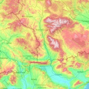
Name: Struma topographic map, elevation, terrain.
Location: Struma, 2340, Bulgaria (40.78616 22.68706 42.61061 23.85707)
Average elevation: 772 m
Minimum elevation: -1 m
Maximum elevation: 2,818 m
Other topographic maps
Click on a map to view its topography, its elevation and its terrain.
Rila mountain range
Rila (Bulgarian: Рила, pronounced [ˈriɫɐ]) is the highest mountain range of Bulgaria, the Balkan Peninsula and Southeast Europe. It is situated in southwestern Bulgaria and forms part of the Rila–Rhodope Massif. The highest summit is Musala at an elevation of 2,925 m which makes Rila the sixth highest…
Average elevation: 2,525 m