
Istanbul topographic map
Interactive map
Click on the map to display elevation.
About this map
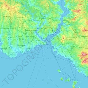
Name: Istanbul topographic map, elevation, terrain.
Location: Istanbul, Fatih, Istanbul, Marmara Region, 34126, Turkey (40.84963 28.80516 41.16963 29.12516)
Average elevation: 55 m
Minimum elevation: -3 m
Maximum elevation: 425 m
Istanbul's weather is strongly influenced by the Sea of Marmara to the south, and the Black Sea to the north. This moderates temperature swings and produces a mild year-round climate with little seasonal temperature variation. Because of its hilly topography and maritime influences, Istanbul exhibits a multitude of distinct microclimates. Within the city, rainfall varies widely owing to the rain shadow of the hills in Istanbul, from around 635 millimeters (25.0 in) on the southern fringe at Florya to 1,167 millimeters (45.9 in) on the northern fringe at Bahçeköy.