
Nassau County topographic map
Interactive map
Click on the map to display elevation.
About this map
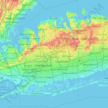
Name: Nassau County topographic map, elevation, terrain.
Location: Nassau County, New York, United States (40.52330 -73.78042 40.96420 -73.42314)
Average elevation: 18 m
Minimum elevation: -6 m
Maximum elevation: 111 m
Other topographic maps
Click on a map to view its topography, its elevation and its terrain.
Manhattan
United States > New York > New York County > New York
Manhattan, New York County, New York, United States
Average elevation: 16 m
New York County
United States > New York > New York
New York County, New York, United States
Average elevation: 16 m
Sullivan County
United States > New York > Sullivan County
Sullivan County, New York, United States
Average elevation: 435 m
North Lake
United States > New York > Greene County > Town of Hunter
North Lake, Town of Hunter, Greene County, New York, United States
Average elevation: 629 m
Hunter Mountain
United States > New York > Greene County > Town of Hunter
Hunter Mountain, Town of Hunter, Greene County, New York, 12450, United States
Average elevation: 1,004 m
Village of Hunter
United States > New York > Greene County > Village of Hunter
Village of Hunter, Town of Hunter, Greene County, New York, United States
Average elevation: 617 m
Village of Monticello
United States > New York > Sullivan County > Village of Monticello
Village of Monticello, Town of Thompson, Sullivan County, New York, United States
Average elevation: 444 m
Sullvan Town Park
United States > New York > Madison County > Town of Sullivan > Village of Chittenango
Sullvan Town Park, Village of Chittenango, Town of Sullivan, Madison County, New York, United States
Average elevation: 161 m