
Ethiopia topographic map
Interactive map
Click on the map to display elevation.
About this map
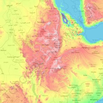
Name: Ethiopia topographic map, elevation, terrain.
Location: Ethiopia (3.39745 32.99758 14.89405 47.98238)
Average elevation: 845 m
Minimum elevation: -123 m
Maximum elevation: 4,296 m
In 2019, archaeologists discovered a 30,000-year-old Middle-Stone Age rock shelter at the Fincha Habera site in the Bale Mountains of Ethiopia at an elevation of 3,469 metres above sea level. At this high altitude humans are susceptible both to hypoxia and to extreme weather. According to a study published in the journal Science, this dwelling is proof of the earliest permanent human occupation at high altitude yet discovered. Thousands of animal bones, hundreds of stone tools, and ancient fireplaces were discovered, revealing a diet that featured giant mole rats.
Other topographic maps
Click on a map to view its topography, its elevation and its terrain.