
Mount Ruapehu topographic map
Interactive map
Click on the map to display elevation.
About this map
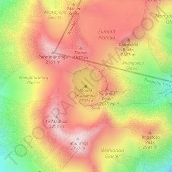
Name: Mount Ruapehu topographic map, elevation, terrain.
Average elevation: 2,474 m
Minimum elevation: 2,077 m
Maximum elevation: 2,755 m
Other topographic maps
Click on a map to view its topography, its elevation and its terrain.
Mount Cook
New Zealand > Canterbury > Mackenzie District
Mount Cook, Mackenzie District, Canterbury, New Zealand
Average elevation: 2,920 m
Donnellys Crossing
New Zealand > Northland > Kaipara District
Donnellys Crossing, Kaipara District, Northland, New Zealand
Average elevation: 219 m