Geolocate

Morocco topographic map

Interactive map

Click on the map to display elevation.

About this map

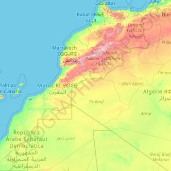
Name: Morocco topographic map, elevation, terrain.

Location: Morocco (21.33653 -17.25515 36.05053 -0.99843)

Average elevation: 369 m

Minimum elevation: 0 m

Maximum elevation: 3,744 m

In the Rif, Middle and High Atlas Mountains, there exist several different types of climates: Mediterranean along the coastal lowlands, giving way to a humid temperate climate at higher elevations with sufficient moisture to allow for the growth of different species of oaks, moss carpets, junipers, and Atlantic fir which is a royal conifer tree endemic to Morocco. In the valleys, fertile soils and high precipitation allow for the growth of thick and lush forests. Cloud forests can be found in the west of the Rif Mountains and Middle Atlas Mountains. At higher elevations, the climate becomes alpine in character, and can sustain ski resorts.

Other topographic maps

Click on a map to view its topography, its elevation and its terrain.

Tameslouht

Morocco > Cercle de Tahannaout دائرة تحناوت

Tameslouht, caïdat de Tameslouhte, Cercle de Tahannaout دائرة تحناوت, Al Haouz Province, Marrakech-Safi, 42312, Morocco

Average elevation: 627 m

Agadir

Morocco > Pachalik d'Agadir ⵍⴱⴰⵛⴰⵡⵉⵢⴰ ⵏ ⴰⴳⴰⴷⵉⵔ باشوية أكادير

Agadir, Pachalik d'Agadir ⵍⴱⴰⵛⴰⵡⵉⵢⴰ ⵏ ⴰⴳⴰⴷⵉⵔ باشوية أكادير, Agadir Ida-Outanane Prefecture, Souss-Massa, Morocco

Average elevation: 131 m

Tinghir

Morocco > Pachalik de Tinghir باشوية تنغير

Tinghir, Pachalik de Tinghir باشوية تنغير, Tinghir Province, Drâa-Tafilalet, 45800, Morocco

Average elevation: 1,352 m

Graizim كريزيم

Morocco > Cercle de Tiznit دائرة تزنيت

Graizim كريزيم, Arbaa Sahel, caïdat d'Arbaa Sahel, Cercle de Tiznit دائرة تزنيت, Tiznit Province, Souss-Massa, 85350, Morocco

Average elevation: 71 m

Casablanca

Morocco > Casablanca

Casablanca, préfecture d'arrondissements de Casablanca-Anfa عمالة مقاطعات الدار البيضاء أنفا, Pachalik de Casablanca, Prefecture of Casablanca, Casablanca-Settat, 20250, Morocco

Average elevation: 56 m