
Guatemala topographic map
Interactive map
Click on the map to display elevation.
Guatemala
All major cities are located in the highlands and Pacific coast regions; by comparison, Petén is sparsely populated. These three regions vary in climate, elevation, and landscape, providing dramatic contrasts between hot, humid tropical lowlands and colder, drier highland peaks. Volcán Tajumulco, at 4,220 metres (13,850 feet), is the highest point in the Central American countries.
About this map
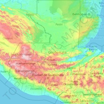
Name: Guatemala topographic map, elevation, terrain.
Location: Guatemala (13.55779 -92.37439 17.81659 -88.21344)
Average elevation: 604 m
Minimum elevation: -2 m
Maximum elevation: 4,131 m