
Peru topographic map
Interactive map
Click on the map to display elevation.
About this map
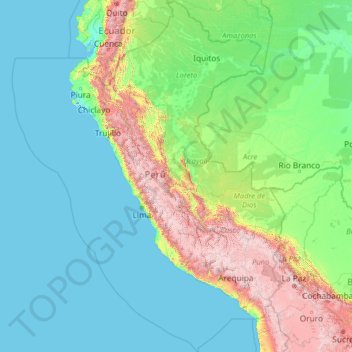
Name: Peru topographic map, elevation, terrain.
Location: Peru (-20.19845 -84.63565 -0.03928 -68.65199)
Average elevation: 645 m
Minimum elevation: -3 m
Maximum elevation: 6,020 m
The combination of tropical latitude, mountain ranges, topography variations, and two ocean currents (Humboldt and El Niño) gives Peru a large diversity of climates. The coastal region has moderate temperatures, low precipitation, and high humidity, except for its warmer, wetter northern reaches. In the mountain region, rain is frequent in summer, and temperature and humidity diminish with altitude up to the frozen peaks of the Andes. The Peruvian Amazon is characterized by heavy rainfall and high temperatures, except for its southernmost part, which has cold winters and seasonal rainfall.
Other topographic maps
Click on a map to view its topography, its elevation and its terrain.
Sacred Valley of the Incas
Sacred Valley of the Incas, Cusco, Peru
Average elevation: 3,808 m
Santiago de Surco
Peru > Lima > Santiago de Surco
Santiago de Surco, Province of Lima, Lima, Peru
Average elevation: 172 m