
Thank you for supporting this site ❤️
Make a donation
Make a donation
Worfiu topographic map
Click on the map to display elevation.
Thank you for supporting this site ❤️
Make a donation
Make a donation
About this map
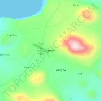
Name: Worfiu topographic map, elevation, terrain.
Location: Worfiu, Shefa Province, Vanuatu (-16.91176 168.53525 -16.87176 168.57525)
Average elevation: 161 m
Minimum elevation: -1 m
Maximum elevation: 479 m
Thank you for supporting this site ❤️
Make a donation
Make a donation
Other topographic maps
Click on a map to view its topography, its elevation and its terrain.
Pele
Vanuatu > Shefa Province > Pilliura
Pélé Island, sometimes spelled Pele in English, is a volcanic island located 11,2 miles north of the island of Éfaté in the Shefa Province of the Republic of Vanuatu. It has a total area of 1.7 square miles, Pélé is inhabited by about 200-220 Ni-Vanuatu villagers residing in the four villages: Worsiviu,…
Average elevation: 18 m