
Make a donation
Chao topographic map
Click on the map to display elevation.
Make a donation
About this map
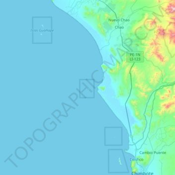
Name: Chao topographic map, elevation, terrain.
Location: Chao, Peru (-9.08028 -79.11583 -8.44028 -78.47583)
Average elevation: 98 m
Minimum elevation: -1 m
Maximum elevation: 1,672 m
Make a donation
Other topographic maps
Click on a map to view its topography, its elevation and its terrain.
Colca Canyon
Peru > Arequipa > Choco > Soro
Colca-Arequipa 14 plains of Majes, it is known as the Majes River, and then is known as the Camana before reaching the Pacific Ocean at the town of that name. The Majes River was believed by the Incas to flow directly into the Milky Way. For this reason, they often put sacrifices and gifts to the gods in the…
Average elevation: 3,169 m
Lake Titicaca
Lake Titicaca has a surface elevation of 3,812 m (12,507 ft). The "highest lake" claim is generally considered to refer to commercial craft. Numerous smaller bodies of water (that are not considered lakes) around the world are at higher elevations. For many years, the largest vessel afloat on the lake was the…
Average elevation: 3,870 m
Make a donation
Pacaya Samiria National Reserve
The annual mean temperature ranges between 20 and 33 °C, while the annual mean precipitation ranges between 2000 and 3000 mm. It is advisable to visit the reserve between May and January. The climograph shown here corresponds to the nearby town of Nauta (93 m of elevation).
Average elevation: 120 m
Cajamarca
Cajamarca (Spanish pronunciation: [kaxaˈmaɾka]; Quechua: Kashamarka; Aymara: Qajamarka) is a department and region in Peru. The capital is the city of Cajamarca. It is located in the north part of the country and shares a border with Ecuador. The city has an elevation of 2,700 metres (8,900 ft) above sea…
Average elevation: 1,456 m
Tambopata National Reserve
The area consists of forested hills and plains, with elevations ranging from 200 to 400 m above sea level.[3] The area presents swamps, oxbow lakes and meandering rivers; the main rivers in the reserve being the Tambopata, Malinowski and Heath rivers.[3]
Average elevation: 239 m
Make a donation
Machu Picchu
Peru > Cusco > Machupicchu > Intihuatana > San Miguel
Animals are also suspected to have migrated to Machu Picchu, as there were several bones found that were not native to the area. Most animal bones found were from llamas and alpacas. These animals naturally live at altitudes of 4,000 meters (13,000 ft) rather than the 2,400 meters (7,900 ft) elevation of Machu…
Average elevation: 2,225 m
Manu National Park
Manu National Park covers an area of 1,716,295.22 hectares (17,162.95 km2) which comprises mountainous areas (traversed by creeks and valleys) with elevations close to 4000 m above sea level and a portion of the Amazon Basin plains.
Average elevation: 1,010 m
Make a donation
Make a donation
Make a donation
Make a donation
Arequipa
This department has a rough topography, which is characterised by heavy layers of volcanic lava covering large areas of its inter-Andean sector. It has deep canyons such as the ones formed by the Ocoña and Majes rivers. Plateaus range in height from medium, such as La Joya, and high-altitude ones such the…
Average elevation: 2,599 m
Make a donation
Province of Chucuito
One of the highest elevations of the province is Chuqi Patilla at approximately 5,200 m (17,100 ft). Other mountains are listed below.
Average elevation: 4,051 m
Make a donation
Make a donation
Make a donation
Make a donation
Make a donation
Make a donation
San Juan de Tarucani
The highest elevation of the district is the Misti volcano at 5,822 m (19,101 ft). Other mountains are listed below.
Average elevation: 4,376 m
Make a donation
Make a donation
Laguna Aricota
Lake Aricota (possibly from Aymara ari pointed, sharp, quta lake) is a lake in Candarave Province, region of Tacna, Peru. It has an elevation of 2,800 metres (9,186 ft) above sea level.
Average elevation: 3,058 m
Make a donation
Make a donation
Make a donation
Chinchaypujio
The district of Chinchaypujio has a 2,000-metre (6,600 ft) altitude spread from south to north; hence, the district is home to multiple climate zones. In the south, the Apurímac River runs at 2,200-metre (7,200 ft) elevation where Banana Isla Maleño and other tropical fruit can be grown, in the north, the…
Average elevation: 3,604 m
Make a donation
Make a donation
Pisaq National Archaeological Park
The town is located in the district of Pisac, province of Calca at the southern end of the Sacred Valley at an altitude of 2,972 metres (9,751 ft), 32 kilometres (20 mi) northeast of Cusco. The town straddles the Vilcanota River with most of the settlement on its right bank, where it is laid out in a grid…
Average elevation: 3,848 m
Make a donation
Huamachuco
Peru > La Libertad > Huamachuco
The hamlets at higher elevations (3900–4000 m.) were bases for their herding of domesticated animals, as agriculture could not survive at those heights. The settlements in the lower elevations (2500–3000 m.) contained large amounts of agricultural tools, showing the importance of crops.
Average elevation: 3,359 m
Make a donation
Make a donation
Make a donation
Make a donation