
Atwood topographic map
Interactive map
Click on the map to display elevation.
About this map
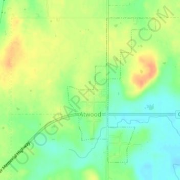
Name: Atwood topographic map, elevation, terrain.
Location: Atwood, Hughes County, Oklahoma, United States (34.94897 -96.34283 34.97062 -96.32671)
Average elevation: 243 m
Minimum elevation: 225 m
Maximum elevation: 262 m
Other topographic maps
Click on a map to view its topography, its elevation and its terrain.
Calvin
United States > Oklahoma > Hughes County
Calvin, Hughes County, Oklahoma, 74531, United States
Average elevation: 232 m
Wetumka
United States > Oklahoma > Hughes County
Wetumka, Hughes County, Oklahoma, 74883, United States
Average elevation: 235 m
Gerty
United States > Oklahoma > Hughes County
Gerty, Hughes County, Oklahoma, United States
Average elevation: 258 m
Horntown
United States > Oklahoma > Hughes County
Horntown, Hughes County, Oklahoma, United States
Average elevation: 255 m
Spaulding
United States > Oklahoma > Hughes County
Spaulding, Hughes County, Oklahoma, United States
Average elevation: 251 m
Dustin
United States > Oklahoma > Hughes County
Dustin, Hughes County, Oklahoma, 74839, United States
Average elevation: 217 m
Yeager
United States > Oklahoma > Hughes County
Yeager, Hughes County, Oklahoma, United States
Average elevation: 245 m
Lamar
United States > Oklahoma > Hughes County
Lamar, Hughes County, Oklahoma, 74850, United States
Average elevation: 259 m
Stuart
United States > Oklahoma > Hughes County
Stuart, Hughes County, Oklahoma, United States
Average elevation: 229 m
Holdenville
United States > Oklahoma > Hughes County
Holdenville, Hughes County, Oklahoma, 74848, United States
Average elevation: 263 m