
Thank you for supporting this site ❤️
Make a donation
Make a donation
Tallebudgera Valley topographic map
Click on the map to display elevation.
Thank you for supporting this site ❤️
Make a donation
Make a donation
About this map
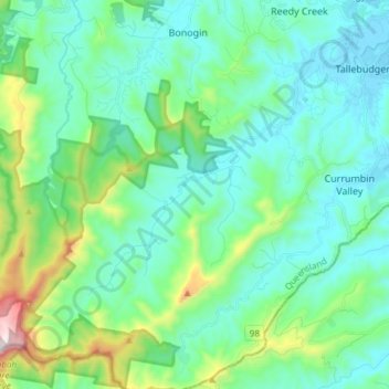
Name: Tallebudgera Valley topographic map, elevation, terrain.
Location: Tallebudgera Valley, Gold Coast, Queensland, Australia (-28.24877 153.29425 -28.11688 153.42628)
Average elevation: 183 m
Minimum elevation: -2 m
Maximum elevation: 930 m
Thank you for supporting this site ❤️
Make a donation
Make a donation
Other topographic maps
Click on a map to view its topography, its elevation and its terrain.