
山西省 topographic map
Interactive map
Click on the map to display elevation.
About this map
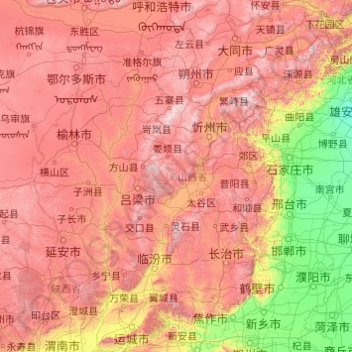
Name: 山西省 topographic map, elevation, terrain.
Location: 山西省, 中国 (34.58407 110.21954 40.74496 114.56551)
Average elevation: 936 m
Minimum elevation: 7 m
Maximum elevation: 2,872 m
山西地处中纬度地带的内陆,在气候类型上属于温带大陆性季风气候。由于太阳辐射、季风环流和下垫面因素影响,山西气候具有四季分明、雨热同步、光照充足、南北气候差异显著、冬夏气温悬殊、昼夜温差大的特点。山西省各地年平均气温介于4.2—14.2℃之间,总体分布趋势为由北向南升高,由盆地向高山降低;全省各地年降水量介于358—621毫米之间,季节分布不均,夏季6—8月降水相对集中,约占全年降水量的60%,且省内降水分布受地形影响较大。
Other topographic maps
Click on a map to view its topography, its elevation and its terrain.