
Thank you for supporting this site ❤️
Make a donation
Make a donation
Rondout topographic map
Click on the map to display elevation.
Thank you for supporting this site ❤️
Make a donation
Make a donation
About this map
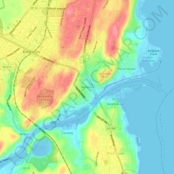
Name: Rondout topographic map, elevation, terrain.
Average elevation: 35 m
Minimum elevation: -11 m
Maximum elevation: 92 m
Thank you for supporting this site ❤️
Make a donation
Make a donation
Other topographic maps
Click on a map to view its topography, its elevation and its terrain.
Sojourner Truth State Park
United States > New York > Ulster County > City of Kingston > East Kingston
Average elevation: 38 m