
Make a donation
Bulawayo topographic map
Click on the map to display elevation.
Make a donation
Bulawayo
By the late 1930s, Bulawayo was no longer the country's biggest city. Influence and activity moved eastwards to the other cities, especially Salisbury, a trend which continues up to the present day. Despite this, after the Second World War, prosperity and population growth revived, as the city became an industrial powerhouse, peaking during the Federal years as new markets opened in Malawi and Zambia. However, Bulawayo trailed the development of other cities notably, Johannesburg, Harare and Cape Town during the same period. In 1940, the Royal Air Force (RAF) launched the Empire Air Training Scheme, and facilitated the construction of multiple bases of the Rhodesian Air Training Group. Bulawayo had ideal conditions, which included having overall flat terrain and being 1,200 meters high in elevation, which made it malaria-free. Three RAF Stations were subsequently established, which included RAF Heany, RAF Kumalo, and RAF Induna, and were all equipped with a hangar and landing ground. Additionally, two bombing ranges were established in the outskirts of Bulawayo, and were named Miasi and Myelbo. In 1943, Bulawayo received city status.
Make a donation
About this map
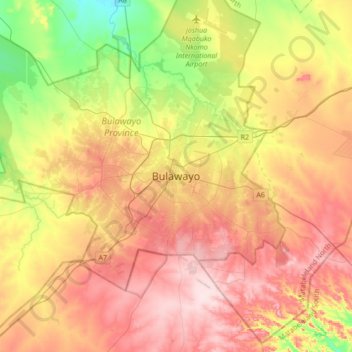
Name: Bulawayo topographic map, elevation, terrain.
Location: Bulawayo, Bulawayo Province, Zimbabwe (-20.31606 28.42871 -19.99606 28.74871)
Average elevation: 1,348 m
Minimum elevation: 1,210 m
Maximum elevation: 1,479 m
Make a donation
Other topographic maps
Click on a map to view its topography, its elevation and its terrain.