
Make a donation
Compass Lake topographic map
Click on the map to display elevation.
Make a donation
About this map
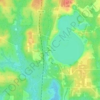
Name: Compass Lake topographic map, elevation, terrain.
Location: Compass Lake, Jackson County, Florida, 32420, United States (30.57269 -85.41270 30.61269 -85.37270)
Average elevation: 66 m
Minimum elevation: 44 m
Maximum elevation: 98 m
Make a donation
Other topographic maps
Click on a map to view its topography, its elevation and its terrain.
Graceville
United States > Florida > Jackson County
Jackson County is a rural community primarily composed of business in agriculture, manufacturing, service, and retail trade. In addition, many government facilities are located within the county, including a federal prison and three state correctional institutions. Elevation ranges from 50 to 330 feet (100 m)…
Average elevation: 48 m
Make a donation
Make a donation
Make a donation
Gulf Islands National Seashore
United States > Florida > Jackson County > Ocean Springs
Average elevation: 20 m