
Tanay topographic map
Click on the map to display elevation.
About this map
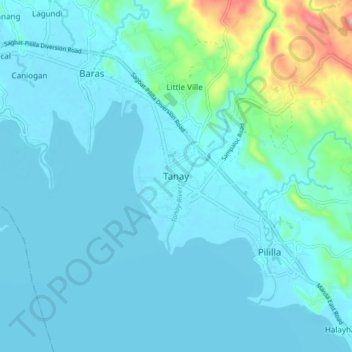
Name: Tanay topographic map, elevation, terrain.
Location: Tanay, Rizal, Calabarzon, 1980, Philippines (14.45854 121.24563 14.53854 121.32563)
Average elevation: 32 m
Minimum elevation: 0 m
Maximum elevation: 256 m
Other topographic maps
Click on a map to view its topography, its elevation and its terrain.
Montalban
Rodriguez is generally very rough in topography, with 83% of its total land area composed of upland areas, hills and mountain ranges. The remaining 17% low-lying terrain and rolling lands are found at the south-western portion of the municipality, along with the northern portions of the Municipality of San…
Average elevation: 230 m